Being aware of altitude shift when navigating a map, especially on untrailed territories, can be essential for pinpointing your exact position and destination. Moreover, taking measurements of trees or an entire forest as a forester or a surveyor, requires a few essential tools, such as an inclinometer, tree calipers and a compass.
All of these tools perform different types of measuring that is essential for the job. You can find them as individual tools, but you’ll also come across 2-in-1 models of compass and inclinometer for more more compact and convenient housing. Let’s get into more detail on how calipers, compass and inclinometer can help with forest surveying and tree measuring.
Measuring Tree Diameter – Calipers
Calipers are used to measure log and tree diameter and they serve a similar purpose as diameter tape, except they’re more precise in the measurements, which is something most professionals require. There are tree calipers in various sizes, made of different materials. Their price depends on the size and the housing, so a small plastic model that reads up to 17 centimetres is significantly less expensive than a caliper that measures up to 90 centimetres.
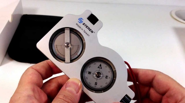
Measuring Tree Height – Inclinometers
Besides the tree’s diameter, the only other relevant measurement is its height, which is measured by an inclinometer. Inclinometers can also measure the slope (which can help when laying out road grades), tree heights on a slope, topographic relief and can be used in preliminary surveying. The measured height is displayed either in percentages or a topographic scale.
In order to accurately use an inclinometer, you have to look in the inclinometer while lining up the instrument’s reference line on the tree’s reference points. This has to be done from a set distance, which is why the measurements are typically displayed on a percent scale. In other words, the distance to measure from is in fractions or multiples of 100.
Measuring Forest Units and Boundary Lines – Compass
It goes without saying that the compasses are an essential tool for forestry. Not only are they useful for defining management units and maintaining and running property boundary lines, but also for orienteering in unknown forests. Professional compasses, like the ones that combine an inclinometer and a compass, feature a set declination. Magnetic declination is the angle of the horizontal plane between the magnetic North and the true North. This angle shifts depending on your position on the Earth’s surface, and it can change over time.


